WalkSydney and BIKEast are pleased to make a joint submission on the Draft Maroubra Junction Masterplan.
We believe that providing and maintaining open and accessible space for the community is very important.
We also believe safe, continuous, and connected walking and cycling routes will encourage more people to participate in active travel – an outcome that is consistent with NSW and Local Government strategies to realise the considerable individual and public benefits of increasing the mode share of active travel (walking or cycling).
As such, we submit the following comments.
Summary of issues
- Improved placemaking – prioritisation of people and community
- Designing priority transport connectivity – based on the Transport for NSW Road User Space Allocation policy and the related Walking Space Guide
- Improved pedestrian facilities – based on the relaxed Transport for NSW policy which allows councils to decide where they install pedestrian crossings on unclassified roads
- Connecting the local cycling network with safe infrastructure – to encourage local trips by active transport
- Lower road speeds to improve safety for all road users and especially pedestrians and people riding bicycles
Important Note: Although the comments below are focussed on the Maroubra Junction Town Centre focus area, they are equally applicable to the Bunnerong Road and Flower Street retail focus areas.
Improved placemaking – prioritisation of people and community
Maroubra Junction is a Place and needs to be planned appropriately, not just as independent functions around a road space.
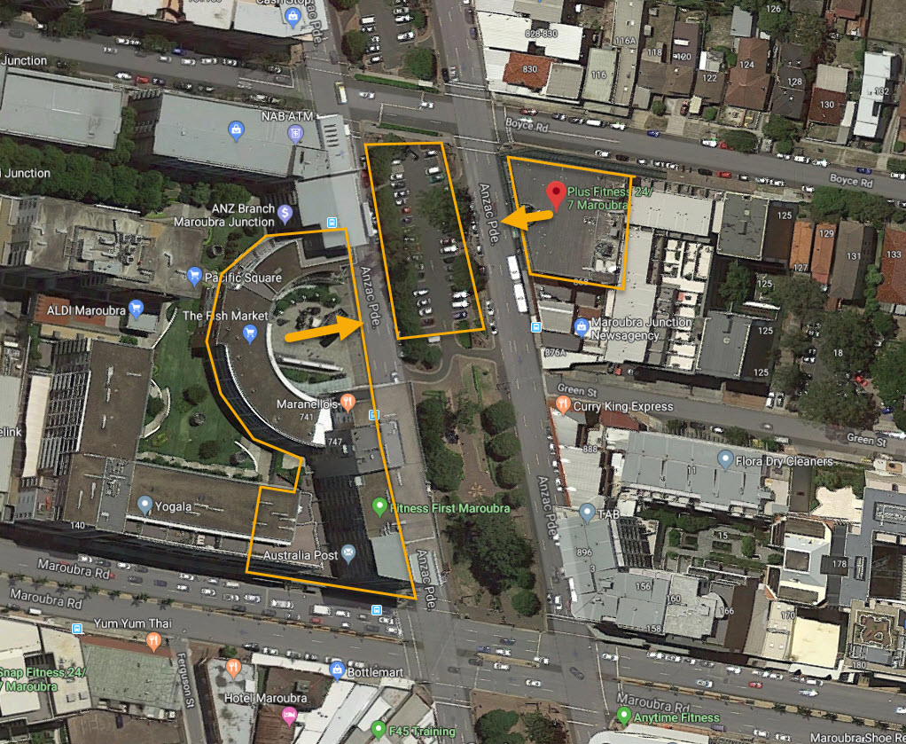
The design of this precinct needs to take into account the significant shopping centres – Pacific Square and Maroubra Plaza with their mid-block entrances, as well as other local services needs to accommodate people movement from all directions.
- Green St on the opposite side.
- Various car parking locations.
- Public transport stops
The provision of car parking in the Anzac Parade median strip also adds to the functional use and access needs around this space.
Maroubra Junction should be considered and planned collaboratively as a place – as part of the Movement and Place framework that focuses on people, rather than just roads or buildings.
“Movement and Place considers the whole street including footpaths, from property line to property line. It takes into account the needs of all users of this space including pedestrians, cyclists, deliveries, private vehicles and public transport, as well as people spending time in those places, whether moving around the place or enjoying street life including outdoor dining, waiting for a bus or watching the world go by.”
The outline document advises that it is “to better balance and align movement and place in the design, planning, construction and operation of NSW’s transport network”.
Maroubra Junction has been identified as a strategic centre with liveability expectations of high levels of amenity, and walkability and being cycle friendly.
“Centres are not just places for economic exchange. They are where communities gather, and where recreational, cultural and educational pursuits are found. They are important to how people participate in community life. This is particularly true in the Eastern City District, where an increasing number of residents live in apartments and rely on public spaces.”
Designing priority transport connectivity
Prioritising equitable access for people walking and cycling with all abilities
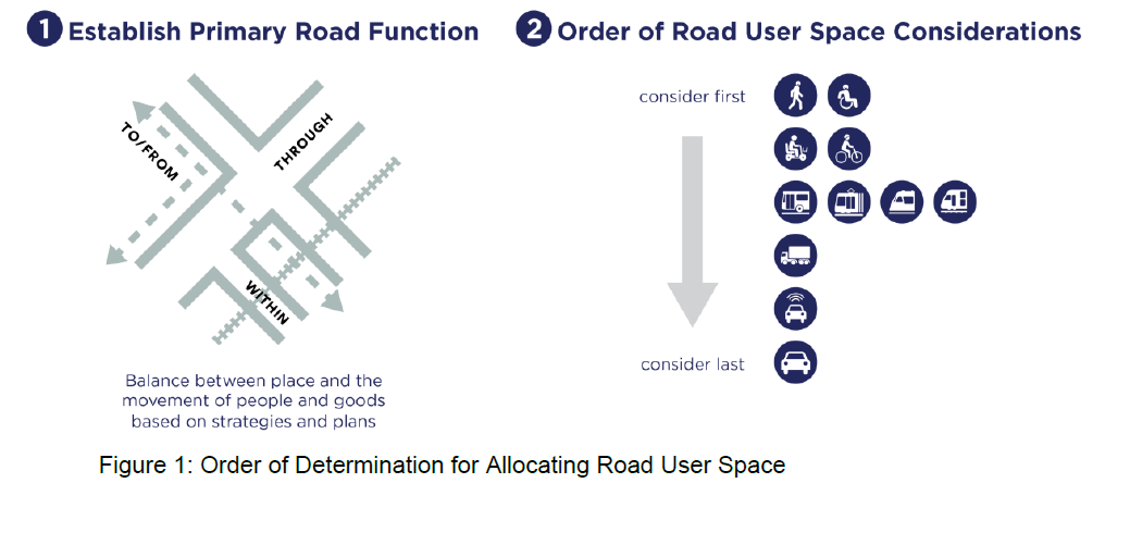
The new Transport for NSW Road User Space Allocation Policy (CP21000) dated 27 Jan 2021, indicates:
When allocating road user space based on the network vision and road functions, consider all road users in order of: walking (including equitable access for people of all abilities); cycling (including larger legal micro-mobility devices); public transport; freight and deliveries; and point to point transport ahead of general traffic and on-street parking for private motorised vehicles
Currently, based on Transport for NSW’s ‘Order of Determining Road Space Allocation’ (refer to the figure below) the three focus areas appear to be designed as Through road functions, prioritising vehicular movement, rather than equitable access for people of all abilities.
Removing punitive pedestrian measures such as fencing.
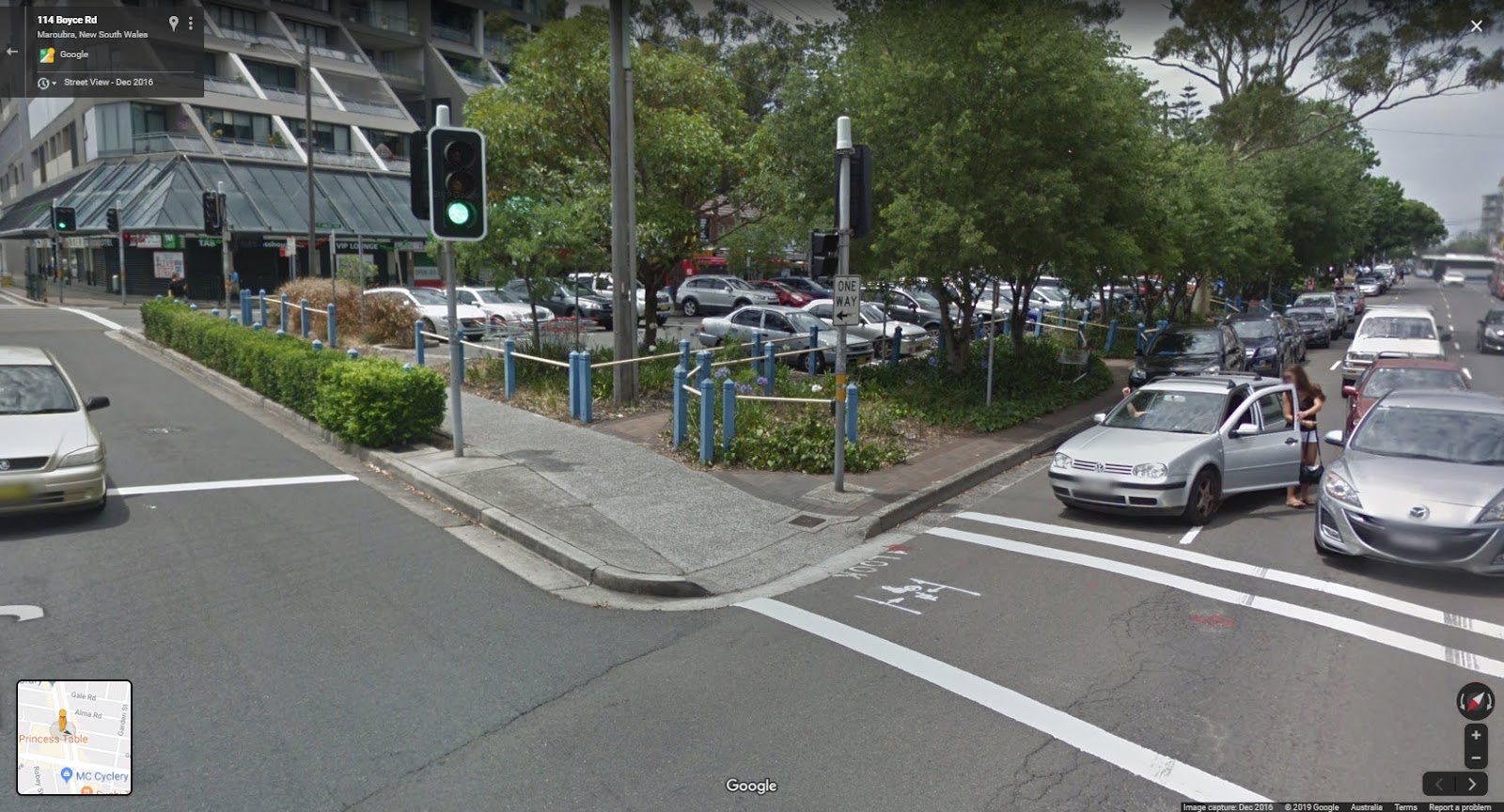
Existing punitive pedestrian measures such as the additional fencing and deterring pedestrian access in 2020 detracts from these strategies, moves and condenses the existing issues further down the road, and will reduce the amenity and sense of community around the location. These also impact all forms of active transport, including cycling access (especially for families with children along the footpaths).
Better strategies to facilitate easier walking will improve safety and in turn support all forms of active transport. This includes:
- Improved intersection design including upgrade of the signal phasing to provide priority for pedestrians
- Improved surrounding footpath surface, width and amenity
The existing fencing from 2020 reduces the space used for being picked up, dropped off, walking and cycling to Pacific Square. This now means there is no suitable pick up and drop off point for people being transported to Pacific Square, who may not be able to travel there independently.
The fencing extension also forces people moving around the road space into the bus stop areas around the heavy bus vehicles. These bus stops experience high traffic.
Fencing is often in-effective in areas of strong pedestrian desire-lines and there is clear evidence that these measures do not result in positive behaviour change.
Improved pedestrian facilities
Improved pedestrian facilities would make walking easier, safer, and more enjoyable and encourage alternative travel paths.
Improve intersection design including upgrade of the signal phasing to provide priority for pedestrians
The length of the block is already longer than usual – about double the surrounding blocks. This creates an unusual length of walking required to reach the location.
Mid-block pedestrian movements are likely exacerbated by the amount of time it takes for the lights to change, as well as the two stage crossing (over 2 cycles) required to cross Anzac Parade.
Improving the signal phasing for pedestrians would encourage easier and safer crossing at the signalised intersections.
Improve the surrounding footpath surface, width and amenity
Many of the surrounding footpaths and pedestrian facilities are outdated and require upgrade.
Some examples below:
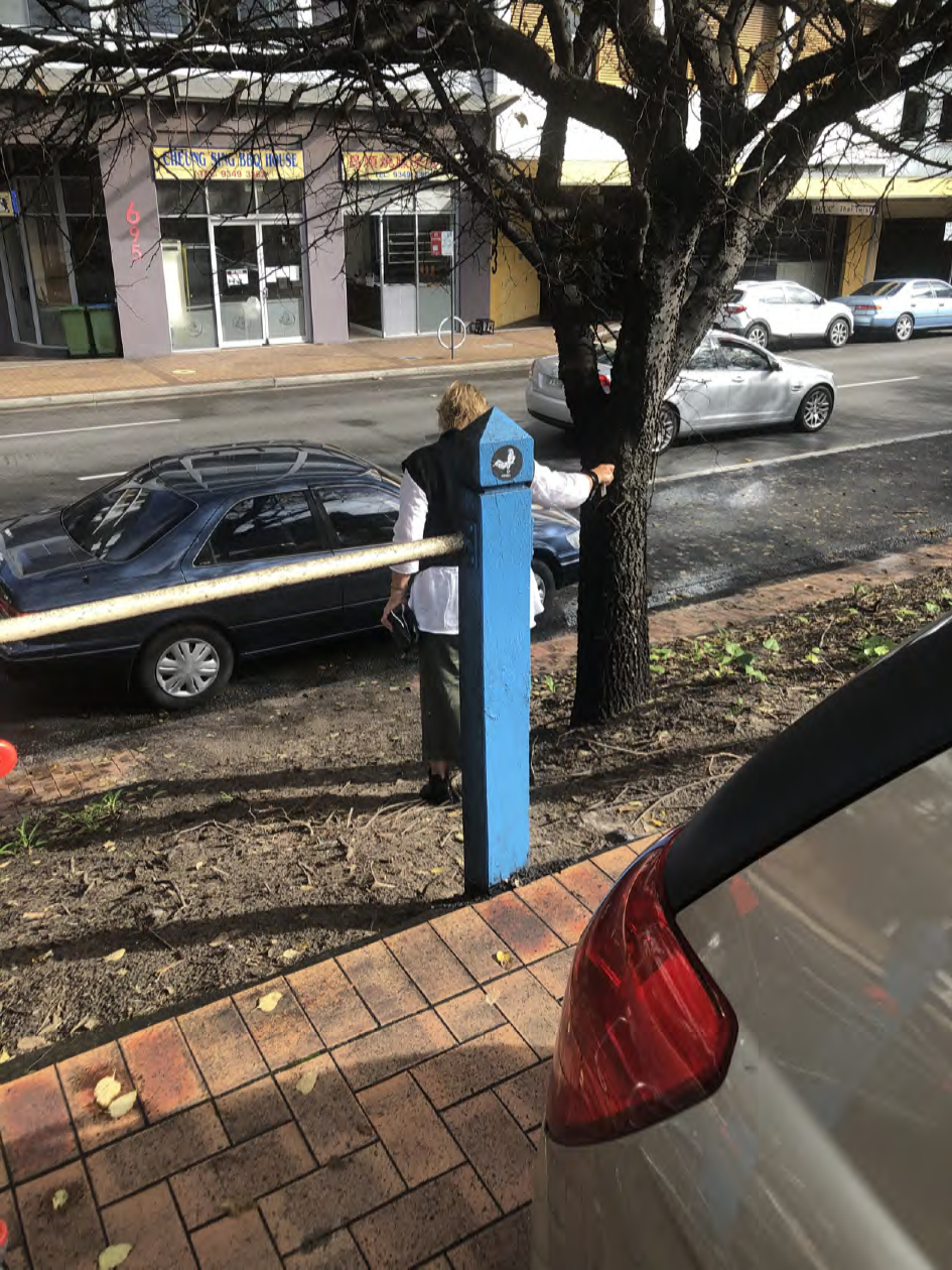
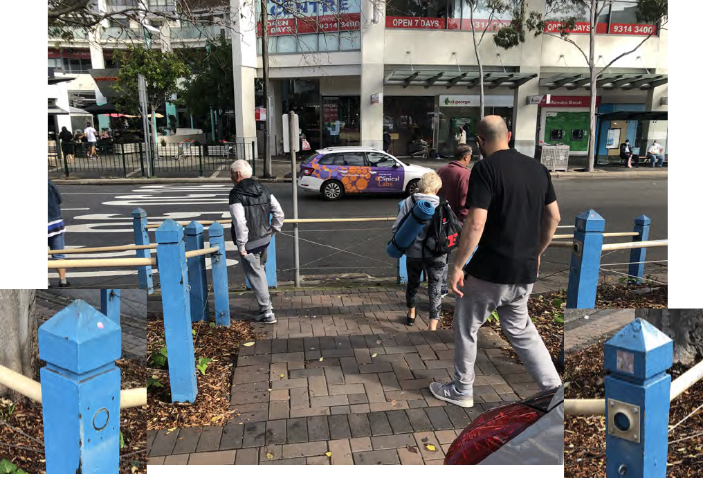
The footpath on the median strip is narrow, difficult to navigate, often overgrown with foliage, and in peak times, often with insufficient space at the intersections for people to wait. The kerb ramps are outdated and do not have guides supporting the direction of travel. Some of the grades along the median footpaths do not comply with the Disability Discrimination Act and some people have difficulty negotiating the steep inclines.
These aspects may mean that people prefer to move towards a safer, wider, space as soon as possible, even if this means crossing mid block. The footpaths around Pacific Square are much wider.
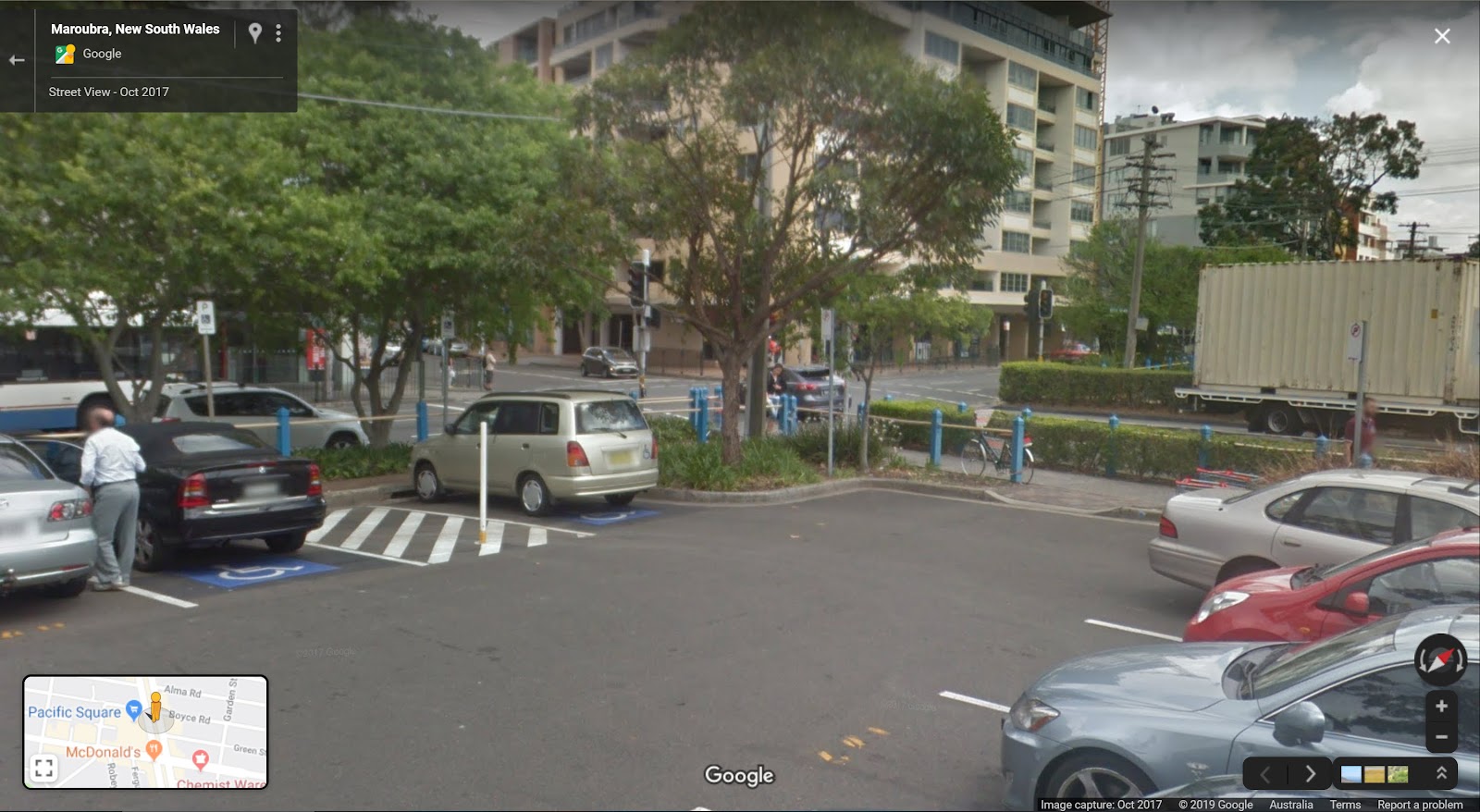
When parking in the median strip, there is only 1 kerb ramp at the Northern end to access the narrow footpaths. This footpath and access is not to current Australian Standard and is hazardous by encouraging walking through the carpark.
There are no pedestrian crossings between the medians even though pedestrians can and do legally cross at these locations.
People may prefer to walk along the wide road surface and cross to Pacific Square or Maroubra Plaza via the shortest distance across Anzac Parade (20m) rather than another whole block (60m) to Boyce Rd crossing (which can add up to 150m). This is quite a substantial difference even without including the time required to wait for the pedestrian lights.
150m to cross at Boyce Rd | 40m to cross directly |
As a result, many people choose to walk through the carpark, due to lack of other pedestrian access.
This is hazardous with vehicles moving in and out.
Connecting the local cycling network with safe infrastructure
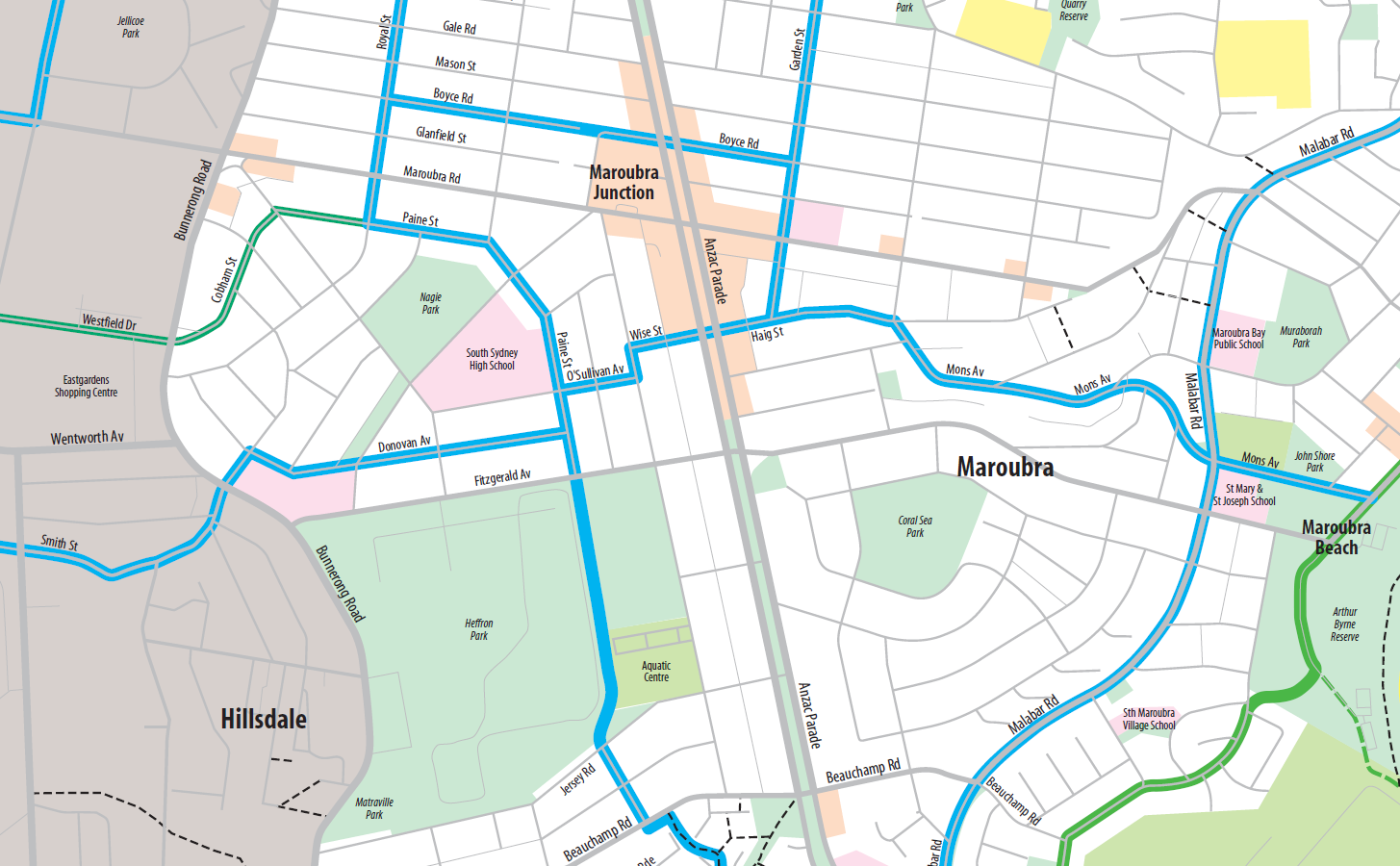
There is noticeable increased traffic congestion around Maroubra Junction. To alleviate this demand, there should be encouragement of local trips by walking and cycling. However, safe and amenable facilities must be provided to support this. Randwick Council Bicycle Plan 2006 (refer to screenshot) indicates an intended cycling route grid around Maroubra Junction.
15 years later, Maroubra Junction still lacks significant safe, protected infrastructure encouraging people of all abilities to cycle for local trips.
Lower road speeds to improve safety
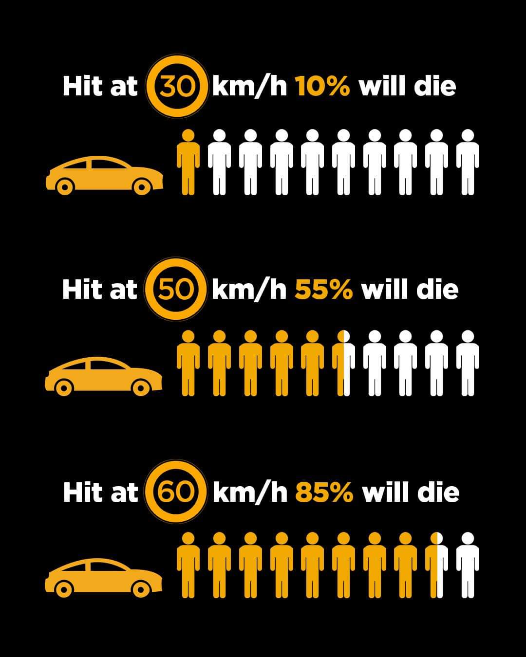
Lower speeds are the easiest way to reduce risk of injury or fatality. The masterplan should follow the initiatives of Transport for NSW trials by reducing the speed limit to 30km/hr and/or nominating this space as a High Pedestrian Activity Area for traffic calming.
We know that reducing the speed limit has a dramatic increase on reducing road fatalities, not to mention injuries.
30km/hr hour is now global best practice and Transport for NSW policy documents are supporting this. 30please.org has more information.
We believe the benefits of active travel to community and worker health, environmental and sustainability community benefits, as well as traffic congestion, are important to the local community, and should be captured in the Maroubra Junction masterplan processes going forward.
Thank you for taking the time to read our feedback.